

PROJECT
FINDMINE
SITUATION
The humanitarian clearance of land mines is still a huge challenge:
-
According to UN requirements at least 99.6% of all mines must be cleared up to a depth of 13 cm,
-
There are different types and sizes of mines (metal, minimum metal, non-metal)
-
Mines were placed in different environments (city, jungle, desert) regularly or irregularly and can be redistributed by erosion and surface movements.

CURRENT
STATUS
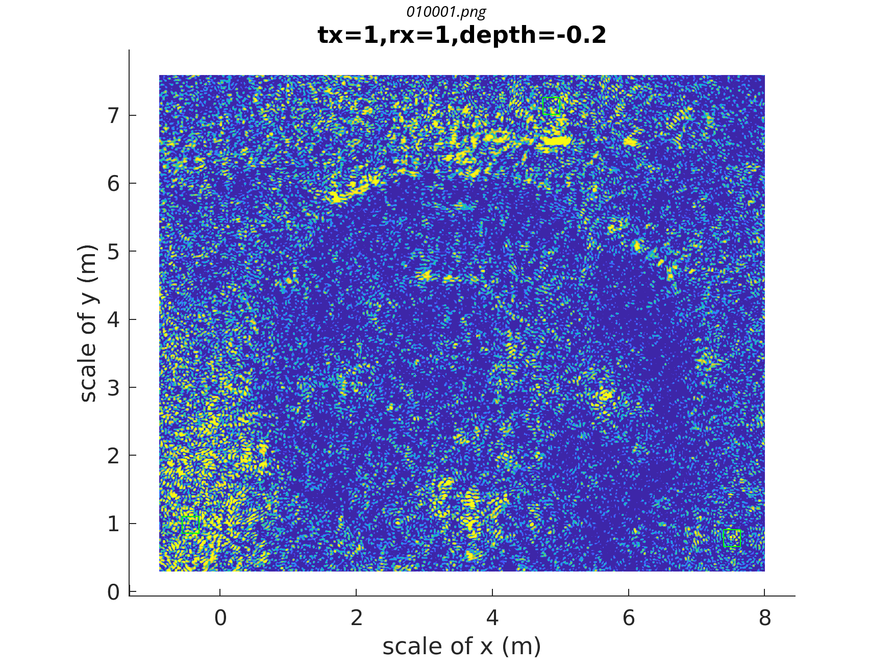
In 2015 a feasibility study proved the possibilities of an unmanned airborne vehicle (UAV) based mine detection system for the automatic detection and localization of landmines. Various Swiss and German universities cooperate since early 2016 on the R&D-project 'FindMine', a UAV-based sensor system for mine detection. The FindMine-System will be used in the process of non-technical survey and land release, which is a very important step of humanitarian mine action. Especially designed new radar sensors are attached to a multicopter-UAV platform. The UAV flies typically 5m above ground level when sensing. It carries the radar sensors and a special real-time kinematic (RTK) global navigation satellite system (GNSS) providing very accurate localization allowing ground penetrating synthetic aperture radar processing (GPSAR). After the processing buried mines can be detected and located. The key issues of the system are localization accuracy, radar dynamic range and sensor synchronization. As a result of excellent research work of the contributing universities over more than 7 years, these key issues are resolved and lots of further research findings are available.
These results have now found a home in the new unit FindMine gGmbH. The start-up-like unit began working in July 2022 and its mission is making from the research results operational systems useful in mine-action and thus a significant contribution to avoid mine victims.
Shareholder of the unit is the Swiss 'Urs Endress Foundation', Arlesheim/Switzerland.
Official Paper - Project FindMine
(c) 2017, 2019
Veröffentlichungen im FindMine Projekt:
"A broadband UAV-based FMCW GPR and the infuence of vegetation"
> Burr, Ralf; et al.; ICMIM 04/2018; 2018
"Lightweight Broadband Antennas for UAV based GPR Sensors"
> Burr, Ralf; et al.; EuRAD 09/2018; 2018
"A Multicopter- based Method for Ground Penetrating Synthetic Aperture Radars"
> Schartel, Markus; et al.; IGARSS 2018; 2018
"Radar-Based Altitude over Ground Estimation of UAVs"
> Schartel, Markus; et al.; Gemic 03/2018; 2018
"UAV-Based Ground Penetrating Synthetic Aperture Radar"
> Schartel, Markus; et al.; ICMIM 04/2018; 2018
"Humanitarian Demining – UAV-Based Detection of Land Mines"
> Gotttwald, Reinhard; et al.; FIG Working Week 2017; 2017
"FindMine – UAV im humanitären Einsatz"
> Mayr, Werner; 178. DVW-Seminar; 2019
https://geodaesie.info/sr/uav-2019-geodaeten-erobern-den-luftraum/8337/1951
"Design of a broadband FMCW GPR for Mine Detection and the influence of vegetation"
> Burr, Ralf; et al.; GeMiC 2019; 2019
"A comparison of ground-based and airborne SAR systems for the detection of landmines, UXO and IEDs"
> Heinzel Andreas; Schartel M., et al.; SPIE2019; 2019
"Revisiting Boustrophedon Coverage Path Planning as a Generalized Traveling Salesman Problem"
> Bähnemann, Rik; et al.; FSR Conference; 2019
https://arxiv.org/pdf/1907.09224.pdf
https://drive.google.com/file/d/1u8CWYJ4HIaom0ELjjhVrPoykOUqNhiQG/view
"Airborne Tripwire Detection Using a Synthetic Aperture Radar"
> Schartel, Markus; et al.; IEEE Geoscience and Remote Sensing Letters (GRSL); 2019
"Position Acquisition for a Multicopter-Based Synthetic Aperture Radar"
> Schartel, Markus; et al.; 2019 20th International
Radar Symposium (IRS); 2019
"UAV-based polarimetric synthetic aperture radar for mine detection"
> Burr, Ralf; et al.; IGARS2019; 2019
"An Experimental Study on Airborne Landmine Detection Using a Circular Synthetic Aperture Radar"
> Schartel, Markus; et al.; arXiv.org; 2020
"Taking a Look Beneath the Surface: Multicopter UAV-Based Ground-Penetrating Imaging Radars"
> Christian Waldschmidt; et al.; ieeexplore.ieee.org; 2022
"Performance Analysis and Simulation of a Continious Wave Metal Detector for UAV Applications"
> Ivan Romero; et al.; ieeexplore.ieee.org; 2022
"Influence of Vegetation on the Detection of Shallowly Buried Objects with a UAV-Based GPSAR"
> Alexander Grathwohl; et al.; ieeexplore.ieee.org; 2022
https://ieeexplore.ieee.org/document/9883635
> Alexander Grathwohl; et al.; oparu.uni-ulm.de; 2022
"Wie entschärft man Landminen?"
> Hansjörg Eberle, Frank Masche.; detektor.fm; 2022


red marked = increased mine risk
red marked = increased mine risk
MDS UE Foundation and Findmine
Jean-Gyl Capt - findmine - Mine Detection Symposium 2019
Jean-Gyl Capt - findmine - Mine Detection Symposium 2019
Urs Endress - future of findmine - Mine Detection Symposium 2019
Hansjörg Eberle - UE Foundation and findmine - Mine Detection Symposium 2019
Jean-Gyl Capt - foundation project - Mine Detection Symposium 2019
COOPERATION WITH


